
Friends of Grasslands
supporting native grassy ecosystems
PO Box 440
Jamison Centre
Macquarie ACT 2614
email: advocacy@fog.org.au
web: www.fog.org.au
Referrals Gateway
Department of Climate Change, Energy, the Environment and Water
Re. Shooting Range Facility Upgrade, Majura ACT, EPBC 2026/10424
Friends of Grasslands (FOG) is a community group dedicated to the conservation of grassy ecosystems in south-eastern Australia - natural temperate grasslands and grassy woodlands. FOG advocates, educates and advises on matters to do with the conservation of these ecosystems, and carries out surveys and on-ground work. FOG is based in Canberra and its members include professional scientists, landowners, land managers and interested members of the public.
While this is a site that can’t be easily visited, the vegetation description appears accurate and appropriate fauna surveys have been conducted. The development footprint largely occurs on disturbed land and appears to have been planned to minimise tree loss.
The value of the development area and whole shooting range as an important regional habitat linkage has however been understated. The development area is part of an important connection between large areas of woodland and forest within the Majura Rifle Range and Kowen escarpment to the southeast and Goorooyarroo and Mulligan’s Flat nature reserves to the northwest.
The Attachment explains what is necessary to maintain connectivity in the ACT, and shows precisely how the proposed action will result in a loss of connectivity.
The proposal is likely to have a significant impact on White Box-Yellow Box-Blakely's Red Gum Grassy Woodland and Derived Native Grassland because it will increase this community’s fragmentation.
If this is not accepted, then given the importance of the shooting range to habitat connectivity, specific measures are needed to avoid a significant impact. ‘Particular manner’ measures along the following lines would need to apply:
1. On a ratio of 10:1, the impact of the loss of any tree must be mitigated by plantings of locally native tree species in locations that enhance the south-east to north-west movement of wildlife across the shooting range. This should involve planting and management sufficient to maintain 30 live trees for the next forty years. By this time, the trees will have been established.
2. The combined groundcover of African Lovegrass, Serrated Tussock and Chilean Needlegrass within the area of developed and indirectly impacted (within a 20 metre buffer) will not exceed three per cent of the ground cover at any time within five years from completion of works. Not only will this prevent the named weed species from becoming abundant in the land identified, it is likely to be the most cost effective way of controlling the occurrence and spread of these weeds to the surrounding areas from the disturbance.
Yours sincerely,
SIGNED
Professor Jamie Pittock
President, Friends of Grasslands
11 February 2026
Attachment: Maintaining connectivity in the ACT
Doerr (2010) reviewed 80 wildlife studies (mainly birds and small mammals) to gain an understanding as to what structural connectivity (typically some form of native vegetation) is required to link habitat patches and enable wildlife to move across the Australian landscape. Structural connectivity includes the concept of wildlife “corridors” (linear, continuous connections between patches), but also encompasses a wide variety of landscape elements in the form of corridors, disconnected linear elements that do not directly connect patches, and “stepping stones”— series of isolated features such as individual trees, shrubs, rocky outcrops or small clusters of these features. Doerr (2010) concluded that most wildlife can move across the landscape provided that a habitat patch was at least 10ha in size, the distance between patches was not greater than 1100m and that there was a stepping stone every 100m (see Figure 1).
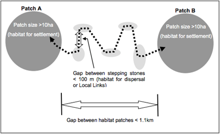
Figure 1: Graphical illustration of average gap crossing thresholds identified in the systematic review by Doerr et al. (2010). The darker patches represent habitat for settlement while the smaller light-grey patches show habitat for dispersal and may consist of either individual paddock trees or small patches (from Barrett and Love 2012).
Barrett and Love (2012) utilised the structural connectivity parameters identified by Doerr (2010) to model least cost movement pathways across the ACT. That is, they plotted all available movement routes and which of these provided the most efficient way to move across the Territory. In the ACT, structural connectivity will be maintained by retaining large habitat patches as much as possible and minimising the total and stepping stone gap differences between patches.
In Figures 2 and 3, green shading indicates functional linkages, the darker the green shading the better the linkages. The purple are 200m gaps, which could become a functional link by planting a small clump of trees in the middle of the gap. The orange outlines mark areas of woodland habitat that with a relatively small effort could become functioning woodland habitat patches. Figures 2 and 3 indicate diametrically the importance of the shooting range as a linkage between two large and ecologically important woodland areas. The link through the shooting range is not the only functional link but there are only a few others and they are all tenuous.
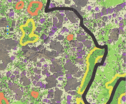
Figure 2: The shooting range link includes the orange circled area towards the centre of the figure
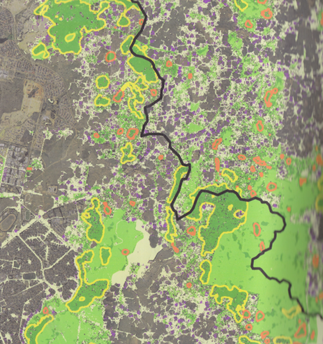
Figure 3: Local Connectivity. Dark Green= high linkage value; Green = medium linkage value; light green = low linkage value; – no green shading = poor linkage value; The map is centred on the development area (after Barrett and Love 2012).
References
Barrett T. and Love J. (2012) Fine Scale Modelling of Fauna Habitat and Connectivity Values in the ACT Region. A report prepared for Conservation, Planning and Research, Environment and Sustainable Development Directorate. ACT Government.
Doerr, VAJ, Doerr, ED and Davies, MJ (2010) ‘Does structural connectivity facilitate dispersal of native species in Australia’s fragmented terrestrial landscapes?’, Systematic Review No 44, Collaboration for Environmental Evidence.. http://www.environmentalevidence.org/SR44.html