
Referrals Gateway
Department of Climate Change, Energy, the Environment and Water
Re. Monaro Rock Quarry Project (EPBC 2025/10355)
Friends of Grasslands (FOG) is a community group dedicated to the conservation of grassy ecosystems in south-eastern Australia - natural temperate grasslands and grassy woodlands. FOG advocates, educates and advises on matters to do with the conservation of these ecosystems, and carries out surveys and on-ground work. FOG is based in Canberra and its members include professional scientists, landowners, land managers and interested members of the public.
The Conservation Council is the leading environmental advocacy organisation in Canberra and hub for over 40 community groups. The Council’s mission is to protect nature and safeguard ecosystems in the ACT and region. We also support broader initiatives to counter regional and global climate change. The Council is a non-profit, non-government organisation that runs campaigns, promotes and upskills local groups, undertakes research, advocates passionately, and engages and informs our community.
FOG and the Council (We, Our) understand rock is needed for the region’s development and that the location of the proposed quarry is suited to meeting this need; at the same time, We are opposed to this proposal because, if it is approved and proceeds, its integrated form, large scale and lengthy duration will result in serious, irreversible impacts. It will impact First Nations Peoples’ heritage, ‘develop’ (clear) 79 ha of the land surface and leave a large pit in the landscape. For three to four decades it will cause pollution, use a lot of water and intensify heavy vehicle movements around a single point. These threats, and others beyond the proponent’s control, compound in the landscape. Nature positive outcomes start with reducing not adding to these threats.
Our focus here is the ecological impacts on matters protected under the Environment Protection and Biodiversity Conservation Act 1999 (EPBC Act), which we summarise in Attachment A. The land clearing proposed will reduce the extent of a grassy ecological community, abbreviated here as Box Gum Woodland (BGW), by at least 22.78 ha. BGW is listed as threatened, protected and critically endangered. The BGW that will remain within the property boundary will be indirectly impacted by a substantial alteration to the surface water drainage pattern and increases in noise, edge effects, vibration, light and air pollution from particulates especially dust.
The proposed action will impact multiple species listed as threatened under the EPBC Act, and that impact will extend beyond the loss of BGW outlined in the previous paragraph because an additional 55.39 ha of Monaro-Queanbeyan Rolling Hills Grassy Forest (PCT 3375) will be lost, and that will likely cause a long‑term decrease in the area of occupancy and in the size of all the threatened species’ populations identified in Attachment A.
We note the proponent concedes some of these impacts will be significant. We are concerned other indirect impacts will also be significant for other listed threatened species, due to dust and the alterations proposed to the surface drainage pattern. The absence of plans setting out detailed mitigation and monitoring regimes is notable; it denies the public an opportunity to examine critical information, reducing the credibility of various claims.
For reasons set out in Attachment B, we found the intensity of the ecological impacts expected from the proposal’s dust difficult to discern. We are concerned about the sensitivity of small woodland birds (Attachment A) whose respiratory systems might not tolerate the level of dust anticipated. Given the lengthy duration of emissions, a precautionary approach is needed. High quality information is required.
One thing is crystal clear, We would prefer that the entire length of the quarry access road be sealed to prevent avoidable dust impacts. Musing frankly, proposing a project of this nature and scale on a partly sealed road appears strategic. Sealing the entire road will not reverse Our opposition to this project due to its other serious irreversible impacts.
Attachment C unpacks Our thinking on planned alterations to the surface water drainage pattern. The scale of take will have significant localised impacts all ecosystems and species downstream. We urge that you obtain an independent expert review of the proponent’s claim there is a low likelihood of impacts to groundwater dependent ecosystems.
All Our concerns are compounded by what We see as an apparent lack of commitment to achieve specific conservation outcomes. For example, the proponent indicates some of the BGW that will remain within the property boundary will not be significantly impacted; however, nowhere does the proponent commit to ensuring that any of the BGW that will remain will retain condition sufficient to continue to be recognised as BGW under the EPBC Act.
We would welcome any opportunity to clarify Our concerns.
As a result of all the above, We recommend the proposal be determined to be clearly unacceptable. If this is not accepted, We recommend the proposal be determined to be a Controlled Action to be assessed by Environmental Impact Statement.
Yours sincerely
|
SIGNED |
SIGNED |
|
Prof Jamie Pittock President, Friends of Grasslands 9 December 2025 |
Dr Simon
Copland 9 December 2025 |
Attachment A: Our understanding of the impacts of the proposal
In the referral, the proponent concedes the proposal’s residual impacts will be significant on:
BGW recognised as protected under the EPBC Act (critically endangered)
- a reduction by 22.78 ha in the extent of PCT3376 Southern Tableland Grassy Box Woodland
- indirect impacts to an additional 5.39 ha of the same ecological community
a plant
- a reduction in the Area of Occupation for Small Purple-pea Swainsona recta (Endangered) by 0.13 ha (31% of its occurrence within the property boundary), all of which meets the definition of ‘habitat critical to the survival of the species’
a bird
- a reduction in foraging habitat for Gang-gang Cockatoo a 48.08 ha (Endangered), all of which meets the definition of ‘habitat critical to the survival of the species’
an insect
- a reduction in the Area of Occupation by 2.35 ha, and fragmentation that may affect the breeding cycle of a population, of Key’s Matchstick Grasshopper Keyacris scurra (Endangered), noting individuals have been confirmed present in an area abutting the proposed mine pit[1]
The proponent’s referral either does not discuss or suggests the following direct impacts are not significant:
on BGW in the ACT
- direct impacts on (clearance of) an additional 0.33 ha recognised as BGW under the EPBC Act in the ACT[2]
- clearance of an unspecified number of remnant native trees within the road corridor with a Diameter at Breast Height (DBH) >30cm, including several with a DBH >50cm and/or hollows[3]
on BGW in NSW
- indirect impacts to an additional 6.94 ha in NSW recognised as BGW under the EPBC Act[4]
on plants
- a reduction in the Area of Occupation for Pale Pomaderris Pomaderris pallida (Vulnerable) by 0.56 ha (22.2% of its occurrence within the property boundary)
on a reptile
- clearing of 39.95 ha (10.9%) of Pink-tailed Worm Lizard Aprasia parapulchella (PTWL) habitat within the property boundary [Vulnerable] – this habitat is reportedly unoccupied but PTWL habitat nonetheless
on birds
- indirect impact over an additional 56.58 ha of Gang-gang Cockatoo foraging habitat, i.e., the loss of 55.39 ha of PCT3375 Monaro-Queanbeyan Rolling Hills Grassy Forest in NSW[5]
- indirect impacts from dust affecting the respiratory systems
of and woodland habitat for:
Regent Honeyeater - highly dependent on flowering eucalypts, dust can coat blossoms, reducing nectar quality and insect abundance
Brown Treecreeper, forages on trunks and ground, dust reduces invertebrate prey and clogs bark crevices
South-eastern Hooded Robin, ground-feeding insectivore, dust suppresses insect populations and interferes with prey detection
Diamond Firetail, seed-eater in grassy woodlands, dust can reduce seed viability and contaminate feeding areas
Southern Whiteface, ground-foraging insectivore, vulnerable to dust impacts on soil invertebrates.
- four Latham’s Snipe (Vulnerable and Migratory) have been seen within the property boundary and were considered likely to have been foraging and roosting.
The impacts of the proposed action on the following species listed as threatened under the EPBC Act will extend beyond the loss of 22.44 ha of BGW recognised as protected under the EPBC Act (in the form of Southern Tableland Grassy Box Woodland (PCT3376)) and include also the loss of a further 55.39 ha of Monaro-Queanbeyan Rolling Hills Grassy Forest (3375):
birds
- Climacteris picumnus victoriae, Brown Treecreeper (south-eastern)
- Stagonopleura guttata, Diamond Firetail (known) (Vulnerable)
- Callocephalon fimbriatum, Gang-gang Cockatoo (Endangered)
- Anthochaera phrygia, Regent Honeyeater (Critically Endangered)
- Lathamus discolor, Swift Parrot (Critically Endangered)
- Melanodryas cucullata cucullata, South-eastern Hooded Robin (Endangered)
- Grantiella picta, Painted Honeyeater (Vulnerable)
- Calyptorhynchus lathami lathami, South-eastern Glossy Black-Cockatoo (Vulnerable)
- Aphelocephala leucopsis, Southern Whiteface (Vulnerable)
mammals
- Pteropus poliocephalus, Grey-headed Flying-fox (Vulnerable)
- Dasyurus maculatus maculatus (SE mainland population), Spotted-tail Quoll (Endangered)
- Phascolarctos cinereus (combined populations of Qld, NSW and the ACT), Koala (Endangered).
We note an entry was made in NatureMapR for Koala (Gula) on 7 November 2025
https://canberra.naturemapr.org/sightings/4709396 but the location was suppressed. The Moderator (Dr Michael Mulvaney) commented that “this sighting was on 6th November 2025 at Googong."
The previous Googong Foreshores records were January/February 2024; two audio records we believe, possibly the same animal, approximate coordinates 149.28 & -35.44 and 149.29 & -35.46.
Attachment B: The intensity of impacts from dust
We found it difficult to discern the intensity of impacts from dust for this proposal for these reasons:
- No site-specific background air quality data was captured for the detailed air quality impact assessment[6]; instead, data was used from a monitoring station 6.4 km away at Monash in the ACT. The maximum particulate levels cited in the proponent’s detailed air quality assessment were captured in April-May 2021 when atmospheric conditions are said to have trapped smoke from residential wood heaters in the Tuggeranong Valley; by contrast, the proposed Project Site is set high in the landscape between two hills. The Monash monitoring station does not capture data for total suspended particulates.[7] To suggest based on the Monash data that air quality thresholds will exceeded from time to time at the proposed Project Site seems inappropriate. In our view, site-specific background air quality data should have been collected.
- Dust deposition data could have been captured at the proposed Project Site at the same time.[8]
- Particulate standards cited relate to sensitive receptor locations expressed in terms of the size of nearby human populations. We are concerned about the sensitivity of some small woodland birds (Attachment A) whose respiratory systems might not tolerate the same level of dust as humans.
- The proponent “proposes to implement an air quality monitoring program which would inform, in real time, management measures to be adopted to minimise particulate emissions at the site to ensure that any additional exceedances would be avoided.”[9] We would prefer to see a detailed air quality management and monitoring program published as part of the draft EIS.
- The proponent indicates the proposal ‘is not expected to result in unacceptable impacts’ from air pollutants including dust.[10] In the absence of a detailed air quality management and monitoring program, the basis of this expectation seems inadequate, based on statements like these:
“Katestone (2011) provides a summary of dust control measures that are routinely considered / applied for open area wind erosion sources.”[11]
“Where land is disturbed, various controls may be applied to minimise the rate of dust emission through wind erosion.”[12]
“Typical measures to control dust generation at extractive industrial sites often include ...”[13]
“The use of a dust shroud when concrete blending at the concrete batching plant, reducing particulate emissions by 70 %”[14]
We want to know what specific mitigations will be applied where, how effective they will be, and how much dust will be released into the atmosphere. In the absence of this baseline, the failure to capture 30 per cent of particulates produced may have a significant impact on protected matters like woodland birds.
- A ‘Summary of emission reduction methods adopted as part of Project operation’ shows the ‘control efficiency’ for each method.[15] If this is based on ‘measures routinely applied’, there really is little here to understand the efficiency of the controls proposed. We would prefer to see firm commitments based on what is actually proposed, sufficient to give the decision maker (and the public) confidence good environmental outcomes will be achieved.
Attachment C: Impacts of planned alterations to the surface water drainage pattern
We have read materials related to the ‘water balance’, to understand the scale of water take.
The proponent asserts rights to harvest (or ‘take’) 38.71ML, based on a Project Site area of 553ha.[16] This level of take appears significant when viewed alongside: the requirements of persons entitled to take surface water for domestic and stock purposes throughout the entire Murrumbidgee II Water Source catchment (Figure 1), 133 ML/year[17]; the estimated volume of surface water available to be shared among users authorised to take water for domestic and stock purposes under access licences across the entire catchment is 25 ML/year[18]; and the estimated volume of surface water available to be shared under local water utility access licences from the entire Murrumbidgee II Water Source catchment is 5 ML/year.[19]
The proponent notes there is no permanent groundwater flow into creeks on the property meaning “it is unlikely” there are groundwater dependent ecosystems that will be impacted by the proposal.[20] This suggests the grassy woodland and grassy forest areas that will not be cleared from the property depend entirely on surface flows. FOG is concerned the proponent does not appear to be considering the need for surface flows into downstream regional ecosystems on and beyond their property.
We note no detailed Surface Water Management Plan been published with the draft EIS.
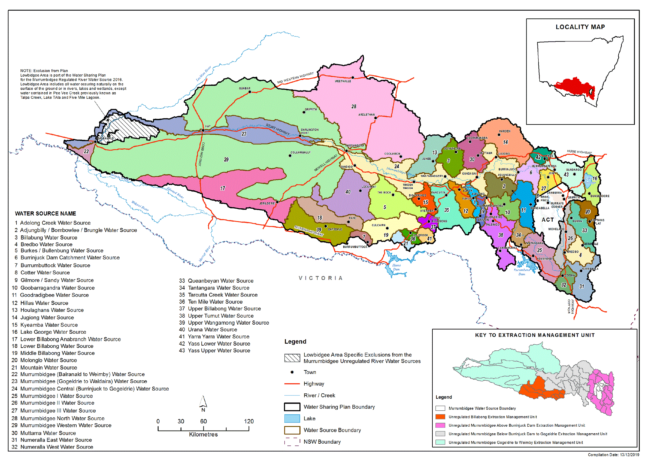
Figure 1: Location and magnitude of Murrumbidgee II Water Source catchment[21].
[1] R.W. Corkery & Co. Pty Limited and Monaro Rock Pty Ltd (2025) (Draft) Environmental Impact Statement for the Monaro Rock Quarry (submitted to the NSW Government), URL: https://majorprojects.planningportal.nsw.gov.au/prweb/PRRestService/mp/01/getContent?AttachRef=SSD-27223807%2120250812T045358.785%20GMT, sections 6.7.4.5 & 6.7.6.1
[2] In R.W. Corkery & Co. Pty Limited and Monaro Rock Pty Ltd n 1, section 6.7.6.4 indicates 0.67 ha of BGW will be cleared in the ACT, not 0.34 ha.
[3] R.W. Corkery & Co. Pty Limited and Monaro Rock Pty Ltd n 1, sections 6.7.4.5 & 6.7.6.1; R.W. Corkery & Co. Pty Limited and Monaro Rock Pty Ltd n 1, section 6.7.6.4
[4] In R.W. Corkery & Co. Pty Limited and Monaro Rock Pty Ltd n 1, section 6.7.6.6 states the total area that will be indirectly impacted is 12.33 ha not 5.39 ha
[5] R.W. Corkery & Co. Pty Limited and Monaro Rock Pty Ltd n 1, section 6.7.6.1
[6] Northstar Air Quality Pty Ltd (Aug 2025) Monaro Rock Quarry Project - Air Quality Impact Assessment (Appendix B to R.W. Corkery & Co. Pty Limited and Monaro Rock Pty Ltd n 1), URL: https://majorprojects.planningportal.nsw.gov.au/prweb/PRRestService/mp/01/getContent?AttachRef=SSD-27223807%2120250812T045402.265%20GMT
[7] R.W. Corkery & Co. Pty Limited and Monaro Rock Pty Ltd n 1, section 6.2.2.1
[8] Northstar Air Quality Pty Ltd n 6, p. 117
[9] Northstar Air Quality Pty Ltd n 6, p. iii, italicisation added
[10] R.W. Corkery & Co. Pty Limited and Monaro Rock Pty Ltd n 1, pp. ES-14 to ES-15, italicisation added
[11] Northstar Air Quality Pty Ltd n 6, p. 35, italicisation added
[12] Ibid
[13] Northstar Air Quality Pty Ltd n 6, p. 32, italicisation added
[14] Northstar Air Quality Pty Ltd n 6, p. 36
[15] Northstar Air Quality Pty Ltd n 6, p. 63
[16] We note the proponent’s referral lists allotments totalling just 484.7 ha.
[17] Water Sharing Plan for the Murrumbidgee Unregulated River Water Sources 2012, https://legislation.nsw.gov.au/file/Murrumbidgee-Unregulated-River-WSP.pdf, viewed 17 Sep 2025, p. 28
[18] Water Sharing Plan n 17, p. 31
[19] Water Sharing Plan n 17, p. 32
[20] Hydrogeologist.com.au (June 2025) Groundwater Impact Assessment, Appendix L to R.W. Corkery & Co. Pty Limited and Monaro Rock Pty Ltd n 1, URL: https://majorprojects.planningportal.nsw.gov.au/prweb/PRRestService/mp/01/getContent?AttachRef=SSD-27223807%2120250812T045404.822%20GMT, p. 47
[21] Murrumbidgee II Water Source catchment is shaded grey and labelled number 26, map sourced on 17 Sep 2025 here: https://jade.io/article/sub/284358/2233745/1